Monday 30 August 2010
Friday 25 June 2010
Mala Fatras - Stefanova - Velky Krivan - Vratna


 A ridge walk
Stefanova - Medziholie - Stoh - Hromove - Chleb - Velky Krivan - Vratna
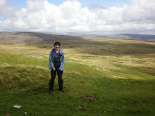
Sometimes, the lovely weather that is always hoped for just doesn't materialise. The recent hike in the Mala Fatras is an example of this. What views? We were actually in the clouds and there was a permanent mist lingering around on the ridges. So no brillant photos of the views from the Mala Fatras this time. Instead I will post some photos of the flowers that can be found in June.
Map used: 1:50 000, The Mala Fatras (Tatra Plan) Not a good map for micro navigation.
For those who are not inclined to hike up (or down) very steep inclines, there is the possibility to take the fast cable car from Vratna and start the ridge walk from the cable car station. It cuts out about 1 hr descent and nearly 2 hrs ascent. This part can be hazardous after rainy periods.
For more information: click here for Vratna Free Time website.
Click here for bus timetable information:
(Vratna is listed under the heading: "Terchová,,Vrátna výťah").
Enjoy!
Friday 11 June 2010
Mala Fatra - info
Thursday 27 May 2010
Babia Gora - Babia Hora
On the border with Poland and Slovakia...

Going up through the forest from the Polish side, early one morning in May...

The paths up are well maintained, sometimes you are stepping over old border posts for Slovakia (S) and Germany too (D)!

Halfway up there is a great Viewpoint, looking back down to the green valleys below.
The higher we got, the landscape changed to an Alpine one, with pine bushes and then..

sparse vegetation and snow still on the ground, (in late May).


Our furry friend the friendly (cunning) fox.

On the border (literally).
 There's no shortage of folks on the summit!

Going up through the forest from the Polish side, early one morning in May...

The paths up are well maintained, sometimes you are stepping over old border posts for Slovakia (S) and Germany too (D)!

Halfway up there is a great Viewpoint, looking back down to the green valleys below.

The higher we got, the landscape changed to an Alpine one, with pine bushes and then..

sparse vegetation and snow still on the ground, (in late May).


Our furry friend the friendly (cunning) fox.

On the border (literally).

 There's no shortage of folks on the summit!
Wednesday 14 April 2010
hiking - saying
“You cannot help someone get up a hill without getting closer to the top yourself.”
- General H. Norman Schwarzkopf
- General H. Norman Schwarzkopf
Friday 9 April 2010
Route Cards

Here is an example of a route card!
WHY? You might know where you are going on the hills /mountains - but does any body else?
The purpose of a route card is to let others know where you are going, so that if you fail to come back off the hills the relevant authorities will know where to start looking for you if are you overdue.
You can make one as simple or as complicated as you want. The essential information to write down, (one copy for you to use on the route and one copy for others to know where you are going!):
Name of the Group Leader;
Other Members in your group;
Start Point + End Point (if different to start point);
What route you plan to take;
Time Out;
Expected Time Back!
Examples of routes cards:
1. Simple
http://www.mountainaid.org.uk/Downloads/Route_Sheet.pdf
2. More info
http://www.sandleheathseascouts.org.uk/route/route-card.pdf
Basic common sense stuff on hiking
http://www.kerrymountainrescue.ie/safety/index.html
from the Kerry Mountain Rescue Team. The same principles apply in the UK, Alps or Slovakia.
from the Kerry Mountain Rescue Team. The same principles apply in the UK, Alps or Slovakia.
Subscribe to:
Posts (Atom)